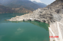
The old town of Tehri lies at the confluence of the Bhagirathi and Bhilangna rivers, the site of the Tehri dam. The town of Tehri was emptied to make space for the Tehri dam, and the population has been shifted to the town of New Tehri. The town is famous as the site of protests against the dam by Sundarlal Bahuguna and his followers during the Chipko movement.
Tehri was the capital of the princely state of Tehri Garhwal in British India, which had an area of 4180 square miles, and a population of 268,885 in 1901. It adjoined the district of Garhwal, and its topographical features are similar. It contained the sources of both the Ganges and the Yamuna, which are visited by thousands of Hindu pilgrims.
Geography
Tehri is located at [show location on an interactive map] 30°23′N 78°29′E / 30.38, 78.48.[1] It has an average elevation of 933 metres (3,061 feet).
onl tehri & new tehri Rajender prasad petwal
15 years ago


